Dreaming of docking your boat steps from your back door and being minutes from downtown Tampa? Buying on Davis Islands delivers that lifestyle, but luxury waterfront also comes with details that can impact value, timelines and insurance. If you are considering a high-end purchase here, you want a clear roadmap to evaluate seawalls and docks, confirm flood and elevation data, and understand what you can remodel or rebuild. This guide gives you a practical, local playbook so you can move forward with confidence. Let’s dive in.
Why Davis Islands for luxury waterfront
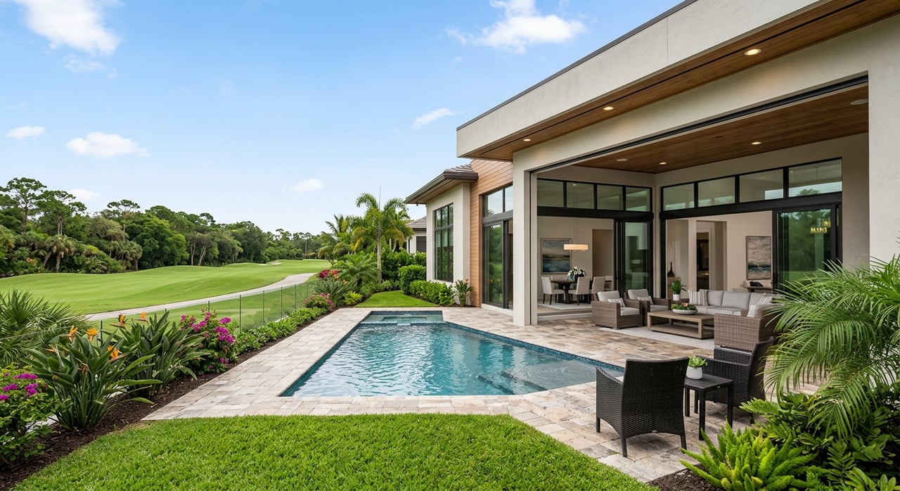
Davis Islands blends a resort-like setting with city convenience. The neighborhood was created in the 1920s, and many Mediterranean Revival buildings on the islands carry historic recognition, with some listed on the National Register of Historic Places. You can explore that history through the National Park Service’s documentation of Davis Islands properties for helpful context on architectural character and preservation. The National Register entry highlights that legacy.
The islands also include a seaplane basin and public mooring facilities. The City has advanced public dock and mooring work in the basin, which can occasionally adjust local navigation patterns or create temporary closures during construction windows. If you plan to rely on direct water access, it is smart to keep an eye on the City’s seaplane basin project page for updates that might affect boating routes or timing.
Choose your waterfront: bay, canal or basin
Not all waterfront is the same on Davis Islands. You will see four general lot types that drive experience and value:
- Bay or open-water frontage. Fastest access to the bay and wide views, balanced by higher wind and boat wake exposure.
- Deep canals or channels. More sheltered water and often adequate depth for larger vessels.
- Protected harbors, coves or mooring basins. Calmest water with limited draft and slower access.
- Interior lots with marina access. No private shoreline, but potential access through a community or public facility.
Match the lot to your vessel’s draft and turning radius, and your preference for panoramic views versus protected mooring. Your agent can help you evaluate specific blocks and orientations that best fit your boating habits.
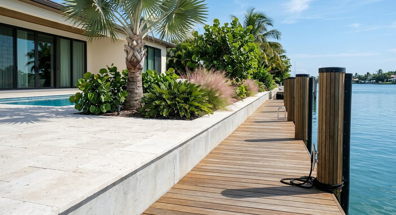
Seawalls and docks: what to verify early
Inspection essentials before you commit
For any waterfront contract, request documentation up front. Ask for a recent seawall inspection, records of repairs, and any as-built drawings and permits for docks or lifts. Local reviewers expect engineered, signed and sealed drawings for jurisdictional seawall work, so prior permit files help you understand what exists and how easily you can maintain or modify it. The Environmental Protection Commission of Hillsborough County (EPC) provides permit checklists and structural requirements that are useful benchmarks for quality. See EPC’s Minor Work guidance for thresholds, drawings and submittals. EPC’s residential marine construction guidance outlines these basics.
Seawall condition: red flags to document
During diligence, catalogue any visible issues along the wall and cap. Common failure indicators include bulging or leaning panels, spalling concrete with exposed rebar, sinkholes or erosion behind the wall, soil piping at joints, and signs that the underwater toe has been undermined. Keep dated photos and request contractor invoices for prior work. These details create leverage for credits or repairs and help engineers price a long-term solution. EPC’s guidance lists typical failure signs and documentation tips.
Who permits docks, lifts and seawalls
Multiple agencies typically touch shoreline work. In Hillsborough County, EPC handles many residential dock and seawall projects under a delegation from the local port authority, and the City of Tampa separately reviews building and structural plans for seawall extensions. Federal review by the U.S. Army Corps of Engineers (USACE) can apply where projects affect navigable waters or sensitive habitats. The state treats most areas waterward of the high-water line as sovereign submerged lands, so authorization is required before altering shorelines or building over those lands. For the legal framework, see Florida Statutes Chapter 253 on sovereignty submerged lands and USACE’s Section 10 permitting overview. For City plan review expectations and inspection stages on seawall work, review the City of Tampa’s seawall extension page. EPC’s Minor Work program sets numeric thresholds that cover many residential docks and seawalls, including structure area, setbacks from riparian lines and limits on extension into channels. EPC’s Minor Work Permit document details these thresholds and setbacks.
Dock design limits you are likely to encounter
Expect limits on the total structure area relative to shoreline width, required setbacks from riparian boundaries, and restrictions on how far you can extend into a channel. Roofs and certain decking types may count toward allowable structural area. Floating docks, pile-supported gangways and lifts are common, but older authorizations sometimes limit what can be added today. Where seagrass or other protected habitat is present, USACE and local rules can add conditions that shape your design or timing. Before you assume any expansion is possible, have your team verify what prior permits allowed. EPC’s Minor Work criteria summarize the typical residential constraints.
Flood, elevation and insurance for luxury homes
Flood zones and what they mean on Davis Islands
Many Davis Islands parcels sit within FEMA Special Flood Hazard Areas, commonly Zone AE. Parts of Davis Boulevard show Base Flood Elevations around 10 feet NAVD88 in recent FEMA studies, but values vary by address. Do not rely on neighborhood averages. Pull the specific FEMA panel, review the community’s Flood Insurance Study table and obtain a current Elevation Certificate to confirm the structure’s relative elevation. FEMA explains how Elevation Certificates are used for compliance and insurance rating. See FEMA’s Elevation Certificate overview. For local context, mapping sources indicate SFHA coverage across portions of the islands, which reinforces the need to validate BFE on your parcel.
Insurance limits and Risk Rating 2.0
NFIP policies for single-family homes cap at 250,000 dollars for the building and 100,000 dollars for contents. For luxury properties, that is rarely enough coverage, so many buyers layer private flood or excess policies. FEMA’s Risk Rating 2.0 prices premiums using property-specific factors like distance to water and elevation, which can materially change costs on coastal parcels. Get quotes early from an insurance broker and align numbers with lender requirements before you remove contingencies. For authoritative details on coverage and rating, see FEMA’s National Flood Insurance Manual.
Community Rating System discounts in Tampa
The City of Tampa participates in FEMA’s Community Rating System, which can reduce NFIP premiums for properties in SFHAs. Recent county mitigation planning documents list Tampa at a CRS Class 5 with an estimated 25 percent premium reduction for SFHA policies. Confirm the current class at the time of quote, since ratings can change. For context, review the Hillsborough County Local Mitigation Strategy plan.
Zoning, historic and redevelopment checks
Davis Islands falls within the City’s Davis Islands Urban Village planning area. Future Land Use Map designations such as R-10, R-20 and RM-24 appear in different blocks, and individual parcels can carry special zoning, PDs or recent amendments. Always verify allowed uses, setbacks and height on the City’s official zoning and FLUM layers, and review council records for recent changes that may affect redevelopment. You can browse City Council agenda records for zoning and FLUM petitions.
Historic context also matters. Several Davis Islands properties are recognized as Mediterranean Revival examples under a National Register Multiple Property Submission, and local historic designation can add permit review and design standards for alterations or demolitions. Confirm whether your target is locally designated, since local rules, not just National Register listing, typically drive what you can change. For background on the MPS and historic context, review the National Register MPS documentation.
Renovation, raising and new construction
If you plan to rebuild or add major improvements, coastal construction standards apply. In V-zones and Coastal A-zones, new work must meet elevated design requirements that reference ASCE 24 and the Florida Building Code. Expect pile foundations, elevated lowest horizontal members, breakaway walls where permitted, flood-resistant materials below prescribed elevations and higher elevation for mechanical systems. Many jurisdictions also require freeboard above BFE. An experienced coastal engineer and builder will design for hydro and scour forces common to the islands. For a concise overview of flood-resistant design standards, see ASCE 24 highlights used in Florida Building Code.
Permitting timeline and sequencing
Waterfront permitting involves parallel steps that benefit from early coordination. A practical sequence looks like this:
- Verify title, easements and obtain a current boundary survey with the mean high-water line shown.
- Order a site survey with shoreline profiles and start preliminary engineering.
- Hold pre-application conversations with EPC and the City to vet concepts.
- Submit to EPC for submerged-lands authorization or a Minor Work Permit while the City reviews structural plans.
- Secure USACE or state verifications if required, then schedule City inspections during construction.
Minor, routine projects can clear in weeks to a few months when complete, while larger or habitat-sensitive work can stretch to several months or longer. After major storms, plan for added backlog. EPC’s submittal guidance outlines applications, thresholds and review paths.
Due diligence checklist for Davis Islands buyers
Use this checklist during your offer window to protect timelines and budget:
- Survey and boundary. Order a boundary survey that confirms the mean high-water line and any recorded bulkhead or seawall easements. EPC’s guidance lists survey expectations for shoreline work.
- Elevation data. Obtain or update an Elevation Certificate and pull the FEMA FIRM panel and Flood Insurance Study table to confirm BFE. FEMA explains EC use and requirements.
- Title and recorded documents. Check for submerged-lands leases, shared seawall obligations or HOA covenants that allocate dock or bulkhead costs. For state ownership and leasing of sovereignty submerged lands, see Florida Statutes Chapter 253.
- Permit history. Request the seller’s files for EPC, City and USACE permits, plus any as-builts. EPC lists the documents typically required.
- Engineering inspections. Engage a marine or structural engineer for above and below water assessment, and a geotechnical engineer if you anticipate foundation or seawall work.
- Insurance and lender. Get NFIP and private flood quotes and confirm lender requirements. Use quotes to set realistic escrow and contingency timelines. FEMA’s manual outlines NFIP coverage and Risk Rating 2.0 fundamentals.
- Environmental constraints. Ask EPC, Port and USACE about seagrass, mangroves or navigation limits that could affect dredging or dock extension. EPC’s guidance describes environmental considerations and setbacks.
- Zoning and historic. Pull City zoning, FLUM and any historic designation records, and review recent council actions for parcel-specific changes. City Council agenda records are a good starting point.
- Contract protections. Add time-bound contingencies to complete the EC, permit pre-checks, engineering inspections and insurance quotes. Assign responsibility for discovered seawall or dock defects in writing.
Key risks and smart negotiation levers
The main risks on waterfront include near-term seawall replacement, limits on dock length or dredging, and flood or surge exposure that can increase premiums and maintenance. Historic review can also shape exterior changes. You can mitigate these with seller credits tied to an engineer’s report, escrows for repairs, or by conditioning closing on delivery of needed permits or lease transfers for submerged lands. Designing for resilience and layering private flood coverage are additional tools. EPC’s published guidance can help you quantify constraints so you negotiate from a position of clarity. Review EPC’s criteria to frame your options.
Your advisory team
Waterfront purchases benefit from a coordinated team. At minimum, plan to engage a waterfront-focused buyer’s agent, a licensed surveyor for the Elevation Certificate and boundary work, a marine or structural engineer with underwater capability, and a geotechnical engineer if foundation or seawall work is likely. Add a maritime or real-property attorney for submerged-lands leases and title items, a permit consultant for EPC and USACE navigation, and a flood insurance broker for NFIP plus private options. Many permit steps are interdependent, and the right team shortens timelines and reduces surprises. EPC’s process overview underscores why complete submittals matter.
Ready to explore luxury waterfront on Davis Islands with a development-informed plan? Start the conversation with a local team that pairs neighborhood expertise with technical insight. Connect with Acropolis Realty Group Tampa to chart your next move.
FAQs
What should I look for when evaluating a Davis Islands seawall before making an offer?
- Ask for a recent marine engineer inspection and review for bulging or leaning panels, spalling concrete, sinkholes behind the wall and joint failures. Request permits and as-builts to confirm what exists and how it was built. EPC’s guidance lists failure signs and documentation.
Who issues permits for new docks or lifts on Davis Islands in Tampa?
- EPC of Hillsborough County reviews many residential docks and lifts under a delegation from the port, the City of Tampa handles building plan review for structural elements, and USACE may verify federal compliance. See EPC’s Minor Work criteria and USACE Section 10 overview.
How do flood zones and Base Flood Elevation affect a luxury home purchase on Davis Islands?
- Many parcels are in FEMA SFHAs, commonly Zone AE, so lenders often require flood insurance. Verify the property’s BFE using the FEMA panel and Flood Insurance Study, and obtain an Elevation Certificate to confirm compliance and pricing. FEMA’s EC overview explains how it is used.
Are NFIP flood insurance limits enough for high-value homes in Tampa?
- NFIP caps are 250,000 dollars for the building and 100,000 dollars for contents, which is often insufficient for luxury properties. Many buyers add private or excess flood to bridge the gap. Risk Rating 2.0 sets premiums based on property-specific factors. Review FEMA’s NFIP manual for details.
Do historic rules restrict remodeling older homes on Davis Islands?
- Some Davis Islands properties have National Register recognition and may also carry local historic designation. Local designation typically triggers permit review and design standards for exterior work, so verify status before planning changes. See the National Register MPS documentation for context.
How long does it take to permit a residential dock or seawall in Hillsborough County?
- Minor, routine projects can clear in weeks to a few months with complete plans. Larger or habitat-sensitive projects can take several months or more, and post-storm backlogs can extend timelines. EPC’s submittal guidance outlines process and thresholds.